Phnom Voar (Deer) Dam
A working reservoir in Kep’s agricultural interior
This pin uses JICA survey coordinates, not a verified vehicle entrance. Confirm access locally.
Explore this place
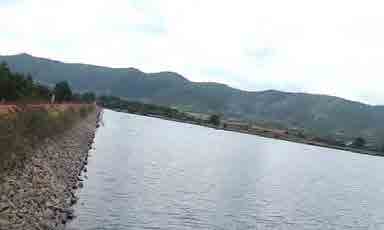
Phnom Voar, also called Deer Dam, is an inland reservoir surrounded by farmland and low hills. It is water infrastructure, not a formal beach or swimming resort.
Observe the reservoir and surrounding cultivation from a safe permitted bank or viewpoint, without interrupting water operations.
About this place and its management
The JICA survey identifies the Cambodian Ministry of Water Resources and Meteorology (MOWRAM) as the authority overseeing the dam at the time of the survey. Current operational arrangements should be checked with the competent local water authority.
A JICA water-supply survey recorded the reservoir as a major agricultural water source and assessed its potential for wider water-supply planning. The report includes a directly labelled photograph of this dam.
Visitor essentials
- Place type
- Agricultural reservoir and water infrastructure
- Address and location
- 10°34′38.02″N, 104°23′04.38″E · Pong Tuek Commune, Damnak Chang’aeur District, Kep Province, Cambodia
- Suggested visit
- Allow a short daylight landscape stop only where public access is permitted.
- Opening hours
- No verified public attraction hours; operational areas may be restricted.
- Tickets and fees
- No reliable sightseeing admission fee is published. Do not enter gated or working areas without permission.
- Getting there
- Navigate to the precise reservoir coordinates or search Phnom Voar (Deer) Dam in Pong Tuek Commune; this is distinct from the broader Phnom Voar mountain area.
Historical background
A JICA water-supply survey recorded the reservoir as a major agricultural water source and assessed its potential for wider water-supply planning. The report includes a directly labelled photograph of this dam.
Architecture and landscape
Notice the engineered embankment and open water basin framed by hills. These practical water-control structures distinguish the site from Kep’s coastal scenery.
Local culture
Reservoir management supports agricultural land and water planning, linking Kep’s rural livelihoods to its landscape.
What to experience
Observe the reservoir and surrounding cultivation from a safe permitted bank or viewpoint, without interrupting water operations.
Photography spots
A JICA report photograph documents the reservoir and embankment; use a wide composition from a stable, permitted shoreline.
Where to stay
Stay in Kep town and allow a separate inland drive.
Visitor feedback
This infrastructure site has no dependable visitor rating for the entire reservoir; do not reuse the Phnom Voar mountain listing.
Suggested route
- Confirm a permitted viewing point with a local driver or authority.
- Observe the embankment and hill backdrop from stable public ground.
- Return along the agreed road well before dark.
Visitor advice
- Stay away from water intakes, steep banks and working structures.
- Do not swim or launch boats without explicit local permission.
- Bring water and arrange return transport.
Frequently asked questions
Is this the same as Phnom Voar mountain?
No. The dam is a specific reservoir within the wider inland region.
Is swimming allowed?
Do not assume it is; request local permission and follow safety signs.
More places around Kep
Address and location
10°34′38.02″N, 104°23′04.38″E · Pong Tuek Commune, Damnak Chang’aeur District, Kep Province, Cambodia
Navigate to the precise reservoir coordinates or search Phnom Voar (Deer) Dam in Pong Tuek Commune; this is distinct from the broader Phnom Voar mountain area.
📍 Find this place on Google MapsThis pin uses JICA survey coordinates, not a verified vehicle entrance. Confirm access locally.
Sources and photograph
Information compiled 17 November 2026; verify access and operating details locally.